


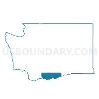
Aldercreek Voting District, Klickitat County, Washington
About
Outline

Summary
| Unique Area Identifier | 687393 |
| Name | Aldercreek Voting District |
| County | Klickitat County |
| State | Washington |
| Area (square miles) | 367.15 |
| Land Area (square miles) | 367.15 |
| Water Area (square miles) | 0.00 |
| % of Land Area | 100.00 |
| % of Water Area | 0.00 |
| Latitude of the Internal Point | 45.92311290 |
| Longtitude of the Internal Point | -120.26819270 |
Maps


Graphs
Select a template below for downloading or customizing gragh for Aldercreek Voting District, Klickitat County, Washington


Neighbors
Neighoring Voting District (by Name) Neighboring Voting District on the Map
- Alderdale Voting District, Klickitat County, WA
- Alfalfa Voting District, Yakima County, WA
- E Toppenish Voting District, Yakima County, WA
- Glade Voting District, Yakima County, WA
- Roosevelt Voting District, Klickitat County, WA
- Woodland Voting District, Klickitat County, WA
Top 10 Neighboring County Subdivision (by Population) Neighboring County Subdivision on the Map
- Goldendale CCD, Klickitat County, WA (6,953)
- South Yakima CCD, Yakima County, WA (3,682)
- Mabton CCD, Yakima County, WA (3,440)
- Horse Heaven Hills Plateau CCD, Klickitat County, WA (919)
- Yakama Nation Reservation CCD, Klickitat County, WA (453)
Top 10 Neighboring Place (by Population) Neighboring Place on the Map
Top 10 Neighboring Unified School District (by Population) Neighboring Unified School District on the Map
- Toppenish School District, WA (14,415)
- Goldendale School District, WA (7,076)
- Granger School District, WA (5,751)
- Mabton School District, WA (3,555)
- Bickleton School District, WA (366)
- Roosevelt School District, WA (207)
Top 10 Neighboring State Legislative District Lower Chamber (by Population) Neighboring State Legislative District Lower Chamber on the Map
Top 10 Neighboring State Legislative District Upper Chamber (by Population) Neighboring State Legislative District Upper Chamber on the Map
Top 10 Neighboring 111th Congressional District (by Population) Neighboring 111th Congressional District on the Map
Top 10 Neighboring Census Tract (by Population) Neighboring Census Tract on the Map
- Census Tract 9501, Klickitat County, WA (8,325)
- Census Tract 9400.03, Yakima County, WA (3,682)
- Census Tract 27.01, Yakima County, WA (3,440)